

BACKGROUND
Geodetic marks are reference points established on the surface of the earth
by state, local, and federal agencies. The geographic location of these
reference points has been established with extreme accuracy, frequently
to a fraction of an inch or so. Geodetic marks are used as starting points
for land survey, map making, engineering, construction, environmental measure
ments and geological studies. Roughly 1 million of these marks have been
selected by the National Geodetic Survey Division (NGSD) to be included
in the National Spatial Reference System (NSRS), sometimes called the
"net". Maintenance and preservation of these marks is of utmost importance
to users of the net and to NGSD, recognizing that many valuable geodetic
marks are destroyed by construction, new roads, erosion, or for other causes.
Our job is to locate each of these marks and report their condition together
with any change in the directions needed to locate them.
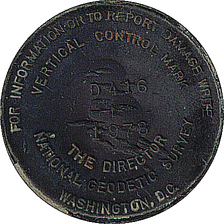 Generally,
the mark (or "station", as it is sometimes called) can be a water tower,
a building, a monument, or even a nautical aid to navigation. Normally,
however, the mark is a round bronze disc, roughly 3 inches in diameter,
firmly imbedded in a square, rectangular, or cylindrical concrete post
usually at ground level or several inches below the surface, though it
may be above ground level as well. Sometimes the mark is set directly in
bedrock, and frequently it is found in the form of a rod enclosed in a
plastic pipe.
Geodetic stations are generally found along roads, highways, property lines,
etc., though many times they are found on high ground such as hills and
mountain tops. Each station has a unique designation, generally having
local significance to near-by residents, places, or business establishments.
You need to know the names of each station along a specific search
route in order to locate the corresponding description provided by NGS.
Descriptions contain directions needed to locate each station and may include
distances along roads or from local landmarks or reference points, nearby
houses, intersections, trees, culverts, bridges, telephone or power poles,
fences, gates, etc.
Geodetic mark recovery is a valuable service to NGSD. participation is
interesting, challenging, personally satisfying and always brings a sense
of accomplishment.
Generally,
the mark (or "station", as it is sometimes called) can be a water tower,
a building, a monument, or even a nautical aid to navigation. Normally,
however, the mark is a round bronze disc, roughly 3 inches in diameter,
firmly imbedded in a square, rectangular, or cylindrical concrete post
usually at ground level or several inches below the surface, though it
may be above ground level as well. Sometimes the mark is set directly in
bedrock, and frequently it is found in the form of a rod enclosed in a
plastic pipe.
Geodetic stations are generally found along roads, highways, property lines,
etc., though many times they are found on high ground such as hills and
mountain tops. Each station has a unique designation, generally having
local significance to near-by residents, places, or business establishments.
You need to know the names of each station along a specific search
route in order to locate the corresponding description provided by NGS.
Descriptions contain directions needed to locate each station and may include
distances along roads or from local landmarks or reference points, nearby
houses, intersections, trees, culverts, bridges, telephone or power poles,
fences, gates, etc.
Geodetic mark recovery is a valuable service to NGSD. participation is
interesting, challenging, personally satisfying and always brings a sense
of accomplishment.
MATERIALS NEEDED FOR PARTICIPATION
-
Compass, preferably hand-bearing. Tape measure (50 to 200 feet).
-
Probe rod, about 1/4 in diameter, and a minimum of 10 inches long, sharpened
to a point. Small shovel and garden trowel (to uncover buried marks).
-
Wire brush and rags (to clean dirt off disk).
-
Flashlight (to provide illumination in deep holes).
-
NOS-USPS Cooperative Charting ID Card . Metal detector (helpful). NGSD
geodetic descriptions (from district Cooperative Charting Chair man).
-
U.S. Geological Survey (USGS) 7.5' Series (Topographic) maps (helpful,
but not essential).
-
Copy of the USPS/NOS Cooperative Charting Manual.
TRANSPORTATION

Transportation is generally by automobile since most marks are located
along roads and highways. Sometimes, you will have to hike to remote locations
well removed from easy access by automobiles and sometimes marks are accessible
only by boat.
PREPARATION
-
Order geodetic descriptions for the geographic area you would like to search.
These are ordered from your district chairman (through your squadron chairman)
and are specified by county within a given state.
-
Collect your computer print out, punch holes in each page and put in a
three ring binder for easy reference. Arrange them in the same order you
plan to search for them.
-
Plot the location of each mark along your search route, if you plan to
search in a systematic manner.
-
Geodetic marks in cities are easy to locate, even though street names are
generally not shown on some maps. If the town or city has an atlas or map,
it will facilitate the search.
-
Mark station locations with prominent crosses on the map and label each
with the station designation for easy access when you are searching.
-
With all geodetic marks plotted, it is easy to plan a day's routing for
bench mark recovery and to see how to get from one location to another.
-
Scale off, with dividers, the distance between each mark and record to
the nearest tenth of a mile, though this information may be given in the
description text. This will be useful as you drive from mark to mark using
the readings on your vehicle's odometer to measure distance.
-
Once you have assembled your group of marks (and have them arranged as
they occur along your search route) you are ready to take to the field
and start the search.
-
Plan the timing of your trips to avoid commuter traffic, especially if
you're searching along heavily traveled roads. Consideration of seasons
also pays off. During the mid year warm months, weed growth (including poison
ivy) is at its maximum and can make bench mark access and visibility very
difficult. Avoid days when the ground is frozen; you will not be able to
dig, even a few inches, into frozen ground to retrieve a bench mark. Trips
after a killing frost would be an excellent choice.
-
Ensure that no mark is knowingly recovered and reported in a time period
less than 5 years.
PROCEDURE
-
Start your recovery trip with a full tank of gas and note your odometer
reading before leaving home and again when you arrive home.
-
Read each description carefully and follow each detail. Use your odometer
reading of distance from established local references as given in the descriptions
or measured on your route map.
-
Locate local references when you reach the station site as outlined in
the "to reach" portion of the descriptions. Be sure to read the latest
dated descriptions for the location of mark, as they may change drastically
from the older description. Use logic and common sense.
-
Ask permission if you intend to search on or near private property or dig
for a bench mark in someone's lawn. Tell them exactly what you are looking
for and where it should be located. Occasionally they will lead you directly
to the mark. Clearly state that your are only inspecting for geodetic marks
and reporting their condition to update their files. Identify yourself
using your NOS-USPS Cooperative Charting Identification Card .
-
Establish LOP's from each local reference point using your compass. Measurement
of distances will help establish the "fix". Always take accurate compass
bearing and distance measurements. The mark should be found at the intersection
of your LOP's.
-
Search the area in the vicinity of the LOP intercept with a probe to find
the exact location using the stated depth as a guide as to how deep to
probe. Alternately, a metal detector can be used to locate the mark if
it isn't too deeply buried in the ground.
-
Look for indentations in the ground or dead grass in the area where you
think the mark may be buried. A survey party may have recently dug for
it, or left a deep hole where the mark may have been located. At times
local surveyors will mark bench mark locations with fluorescent orange
paint or fluorescent orange tape on stakes or with the letters "BM" (i.e.,
bench mark) and an arrow marked with white, orange, or yellow paint on
a nearby concrete wall or rock outcroppings.
-
In some cases, the mark will be located near a "witness post", i.e., a
vertical 3-4 foot post made of metal, plastic, fiberglass, or wood, usually
with a white rectangular sign (8" X 11") alerting the observer that a mark
is nearby. Newer witness posts (sometimes referred to as 'Carsonite' witness
posts) are made of fiber glass and are bright orange with the NOAA logo
 and a short message. Recognize that many local landmarks may -have disappeared
or been altered since the description was written. (Some descriptions were
written more than 100 years ago!) Always start the search using the most
recent description, generally found as the last entry in the "to find'
portion. Consider that occasionally the description was typed incorrectly
or a reverse azimuth reading was recorded. A highway, bridge or power line
pole may have been moved, widened, relocated or removed. Try to cut a reasonably
small plug when uncovering marks in an established lawn. Always refill
holes you dig.
and a short message. Recognize that many local landmarks may -have disappeared
or been altered since the description was written. (Some descriptions were
written more than 100 years ago!) Always start the search using the most
recent description, generally found as the last entry in the "to find'
portion. Consider that occasionally the description was typed incorrectly
or a reverse azimuth reading was recorded. A highway, bridge or power line
pole may have been moved, widened, relocated or removed. Try to cut a reasonably
small plug when uncovering marks in an established lawn. Always refill
holes you dig.
-
When looking for very old bench marks, such as those located in a post
office wall in a small town; remember that the operating post office may
have moved 2 or 3 times in the meantime. Postmasters are usually helpful,
but it pays to ask the oldest person you see in the area. Asking questions
from local residents frequently results in voluntary assistance in the
search. Occasionally airport security guards will drive you inside the
length of an airfield to help in your search.
-
Make notes in the margins of your printed description pages next to each
bench mark. Give the date, condition and details of your inspection and
description changes.
-
Read and check the inscription on the casting and check against the description
to be sure the correct mark has been located after it has been found and
exposed.
Determine and record the condition of the mark as follows:
-
Good...disk is in good condition, easily read, with no signs
of having been moved.
-
Poor....disk shows evidence of having been moved or is severely
damaged mechanically, scuffed, eroded or corroded.
-
Not found...the disk cannot be located. Use this category
if you find that the description places the mark under a concrete pad,
roadway, or in an otherwise inaccessible spot.
-
Destroyed...disk is found and is physically removed from
the site by you. This disk should be returned to NOS as part of your report.
Note in your report that you have recovered and are returning the disk
to NOS.
NGS Searchable Database (Nationwide)

NGS Searchable Database (Nationwide) - Use this link to find all markers within 2 miles
of your house or location (you'll need your latitude and longitude, see
below. Use the second link to print the information on a single PID.
http://www.ngs.noaa.gov/cgi-bin/ds_radius.prl
NGS Data Sheet By Area, a Single PID Data Sheet
http://www.ngs.noaa.gov/cgi-bin/ds_pid.prl
Resources for determining your latitude and longitude
Here are some ways to determine your latitude and longitude.
If you need to convert Lat/Lon from decimal format (ex N40.260302 or N40260302) to Degrees/Minutes/Seconds
format (N40 Degrees, 15 Minutes, 37.0872 Seconds or 40° 15' 37.0872), a converter can be found at: http://www.fcc.gov/mb/audio/bickel/DDDMMSS-decimal.html
************************************************************************
eMail WebAdmin
[
Home
| Crown| Officers |
Ship's Log| Education
| USPS | Links
]